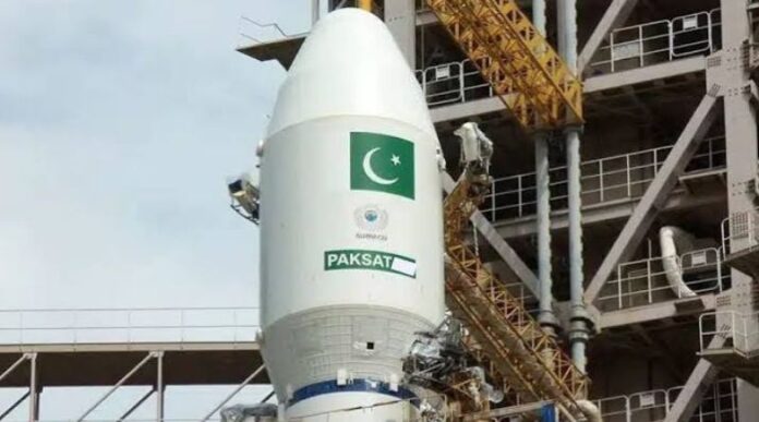

Pakistan is preparing to spend around Rs. 37 billion on a new satellite project as the country continues to expand its space and communication capabilities. The project is expected to support Pakistan’s growing needs in communication, technology, research, remote sensing, and other space-related areas.
The planned investment shows that Pakistan is giving more attention to space technology and satellite-based services. Satellites have become an important part of modern life, helping countries improve communication networks, monitor weather, study the environment, manage agriculture, and support national development projects.
The new project is expected to add to Pakistan’s existing space programme and strengthen the country’s ability to use satellite technology for different purposes.
Rs. 37 Billion Allocated for Satellite Development
According to the plan, Pakistan will spend approximately Rs. 37 billion on the new satellite project. The large investment reflects the growing importance of space technology for the country.
The project is being considered at a time when Pakistan is trying to improve its digital infrastructure and make greater use of modern technology. Satellite systems can provide services in areas where traditional communication networks are difficult or expensive to develop.
For a country like Pakistan, which has large rural areas, mountainous regions, deserts, and remote communities, satellite technology can play an important role in connecting people and supporting development.
The project is also expected to help Pakistan increase its technical knowledge and experience in the space sector. Developing and operating satellites requires expertise in electronics, communication systems, software, engineering, data processing, and other technical fields.
Growing Importance of Satellite Technology
Satellites are no longer used only for scientific research or military purposes. They have become a major part of everyday communication and economic activity.
Satellite technology supports television broadcasting, navigation, weather monitoring, internet services, emergency communication, mapping, agriculture, and environmental studies.
Modern satellites can collect large amounts of information about the Earth. This information can help governments understand changes in land, water, forests, crops, and weather patterns.
Pakistan can also benefit from these capabilities. Satellite images can help authorities monitor floods, droughts, forest areas, glaciers, crops, and other natural resources.
The new investment could therefore support several areas at the same time rather than being limited to one specific use.
Support for Communication Services
One of the major advantages of satellite technology is its ability to provide communication services over large distances.
Traditional communication networks depend heavily on towers, cables, fibre-optic connections, and other infrastructure. Building such systems across difficult terrain can take considerable time and money.
Satellites can provide coverage over wide areas from space. This makes them useful for remote locations where normal infrastructure is not easily available.
Pakistan has many areas where people still face challenges in accessing reliable digital and communication services. Satellite-based systems could help reduce this gap and provide better connectivity to underserved regions.
Improved satellite communication could also be useful during emergencies. Natural disasters such as floods, earthquakes, and landslides can damage roads, mobile towers, electricity systems, and fibre connections. In such situations, satellite communication can provide an alternative way to maintain contact.
Help for Agriculture
Pakistan’s economy has a strong connection with agriculture, making satellite-based information particularly useful.
Satellite images can provide information about crop conditions, soil, water use, and changes in agricultural land. Such information can help farmers and government departments make better decisions.
For example, satellite data can be used to identify areas facing water shortages or monitor the condition of crops over large regions.
It can also help authorities estimate agricultural production and identify areas affected by floods, drought, or other problems.
With better access to satellite information, Pakistan could improve the way it monitors agricultural land and manages natural resources.
Better Disaster Management
Pakistan frequently faces natural disasters, including floods, earthquakes, landslides, and extreme weather events.
Satellite technology can help authorities monitor such events from space. During floods, satellite images can show which areas have been affected and how the situation is changing.
This information can be useful for rescue teams and government departments working on emergency response.
Satellite data can also help authorities prepare maps of affected areas and identify locations that may need immediate assistance.
The new project could therefore contribute to Pakistan’s disaster management capabilities and improve the country’s ability to respond to emergencies.
Monitoring Weather and Climate
Weather forecasting is another important area where satellites play a major role.
Weather satellites can collect information about clouds, storms, rainfall, temperature, and other conditions. This data can support weather forecasting and help authorities prepare for severe weather.
Pakistan has experienced serious weather-related challenges in recent years. Heavy rainfall and floods can cause major damage to homes, roads, crops, and infrastructure.
Better access to satellite information could support early warning systems and help authorities respond more quickly to dangerous weather conditions.
Satellite technology can also help scientists study long-term climate changes and their effects on Pakistan.
Strengthening Pakistan’s Space Programme
The Rs. 37 billion project is also important because it can contribute to the development of Pakistan’s wider space programme.
Pakistan has been working on space-related projects for decades. The country has launched and operated satellites for communication, remote sensing, and other purposes.
The new investment can provide an opportunity to further develop this capability.
Building satellites and managing space missions also helps create a skilled workforce. Engineers, scientists, software developers, researchers, and technicians can gain valuable experience through such projects.
This can encourage young people in Pakistan to choose careers in science, technology, engineering, and mathematics.
Opportunity for Local Technology Industry
A major satellite project can also create opportunities for local companies and technology professionals.
Satellite development requires many different types of equipment and services. These include electronic components, software, communication systems, testing equipment, data processing tools, and ground-based systems.
If more local companies become involved in the space sector, Pakistan could gradually develop a stronger domestic space technology industry.
Local universities and research institutions could also benefit from greater cooperation with government agencies and space organisations.
Students and researchers could get opportunities to work on real-world projects and develop practical skills.
Over time, this could help Pakistan reduce its dependence on outside expertise in some areas of space technology.
Satellite Data Can Support Urban Planning
Satellite images are also useful for studying cities and their growth.
Pakistan’s major cities are expanding rapidly. This growth creates challenges related to roads, housing, water supply, waste management, transport, and other public services.
Satellite data can help authorities understand how cities are expanding and where new development is taking place.
This information can support better urban planning and help government departments monitor changes over time.
Satellite images can also be used to identify changes in land use and monitor areas where construction is increasing.
Benefits for Environmental Monitoring
Environmental protection is another area that can benefit from satellite technology.
Satellites can monitor forests, rivers, lakes, glaciers, wetlands, and other natural areas. They can help identify changes that may not be easy to observe from the ground.
Pakistan has important natural resources that require regular monitoring. Satellite data can provide a wider view and help authorities understand environmental changes.
It can also support research into pollution, deforestation, water resources, and climate-related changes.
Building a Stronger Digital Future
Pakistan is currently working to expand its digital economy and improve access to technology. Satellite infrastructure can become another part of this wider digital development.
Reliable communication is important for businesses, education, healthcare, banking, e-commerce, and government services.
In remote areas, satellite connectivity could help bring digital services to communities that are not fully connected through traditional networks.
This could be particularly useful for schools, health centres, government offices, and other important facilities located far from major cities.
Investment Comes With Long-Term Goals
Spending Rs. 37 billion on a satellite project is a major investment. However, space projects are usually designed with long-term goals in mind.
Satellites can remain useful for several years, while the knowledge and technical skills gained from their development can continue to benefit the country for much longer.
The project may also encourage further investment in Pakistan’s space sector.
As countries around the world increase their use of satellite technology, Pakistan also needs to develop the ability to compete and cooperate in this field.
Need for Effective Use of the Investment
While the project offers several possible benefits, proper planning and management will be important.
A large investment in space technology needs clear targets, strong technical oversight, and proper use of resources. The benefits should reach different parts of the country and support practical national needs.
It will also be important to ensure that satellite data is effectively shared with the government departments and organisations that can use it.
Simply putting a satellite into orbit is not enough. Ground systems, data processing, skilled workers, maintenance, and long-term planning are also needed to get maximum value from the project.
A Step Toward Greater Space Capability
Pakistan’s planned Rs. 37 billion satellite project represents a significant step in the country’s efforts to strengthen its space and technology capabilities.
The project has the potential to support communication, agriculture, weather monitoring, disaster management, environm
Read Also: check